
Can I Have a Goat on My Property?
Architectural Design and the Hidden Rules of Land Use: Animals, ADUs, and More

Have you ever wondered if you’re allowed to keep animals on your property, install that garden shed you’ve been wanting, or even add an ADU for extra monthly income? The answers and information you need are publicly available. If you know where to look of course!
The first part of our design process is the pre-design phase. This phase allows us to research a project and understand the property before actual designing begins. During this phase, we get to know the client, their property, and their project goals. A crucial part of this process is completing a land use study, which involves researching the factors that impact what can and cannot be done on a property. We examine what the city or county allows and prohibits, environmental factors such as floodplains and steep slopes, and the availability of utilities on-site and how new utilities would be brought in.
The purpose of this write-up is to inform you about the land use study service we provide, the benefits of a land use study, and to share the sources and types of information that are readily available to the public about properties.
What is a land use study?
A land use study is a comprehensive analysis of a specific parcel of land to determine its current and potential uses. This study involves gathering and analyzing various types of data to understand the characteristics, restrictions, and opportunities associated with the land. We use a wide range of sources to gather all the information we can about a particular parcel.
To start a land use study, we determine the address and owner of the property, typically provided by our client. We then identify the Authority Having Jurisdiction (AHJ) for the property. This starter information leads us to deeper sources of information.
Authority Having Jurisdiction: This is the governmental agency or authority that enforces regulations and codes on the parcel of land. This could be a city, county, or state agency. The AHJ reviews any new construction or activity on the land. For example, if your land is in the City of Leavenworth, you will apply to the City of Leavenworth for a building permit. Counties have maps available to show the boundaries of jurisdictional areas.
Assessor’s website: We use this to find additional property data such as the owner, owner address, and parcel size. This site also provides information about existing structures on the property and past tax and sales information, which is helpful in researching the property’s history.
Recorded documents: Legal documents recorded with the county or city, such as deeds, easements, and covenants. Each County has a collection of recorded documents available to the public. These documents provide information about property rights and restrictions imposed on the land. Each AHJ has a database of recorded documents. We review all recorded documents related to the property to identify any easements that might limit the location of a new project.
Covenants: These ensure uniformity and protect property values by regulating the use, appearance, and maintenance of properties. We review covenants found in property deeds, to understand any aesthetic restrictions on a design or other restrictions legally bound to the property. Property covenants, often part of Covenants, Conditions, and Restrictions (CC&Rs), are rules set by a developer, homeowners’ association (HOA), or property owners to maintain a certain standard within a community. They often include restrictions to building height, materials, aesthetics, and construction duration. Understanding property covenants is crucial for homeowners to ensure compliance and avoid potential legal issues.
Property plats: These are detailed maps that show the divisions of a larger parcel of land into individual lots. It is used to show how a larger parcel of land is divided into smaller lots. Understanding property plats can be very useful whether you’re buying property, resolving boundary disputes, or planning development projects.
GIS maps: GIS technology collects, manages, and analyzes spatial and geographic data, providing detailed maps and data layers that show various land features, such as topography, vegetation, and infrastructure. Each jurisdiction has its own set of mapping resources, so the sources we use depend on the property location. We use the GIS map provided by the Authority Having Jurisdiction (AHJ) to view information about the property, such as zoning, environmental factors, fire districts, existing utilities, and more. For example, Chelan County has an excellent GIS map that we use for much of our local information gathering.
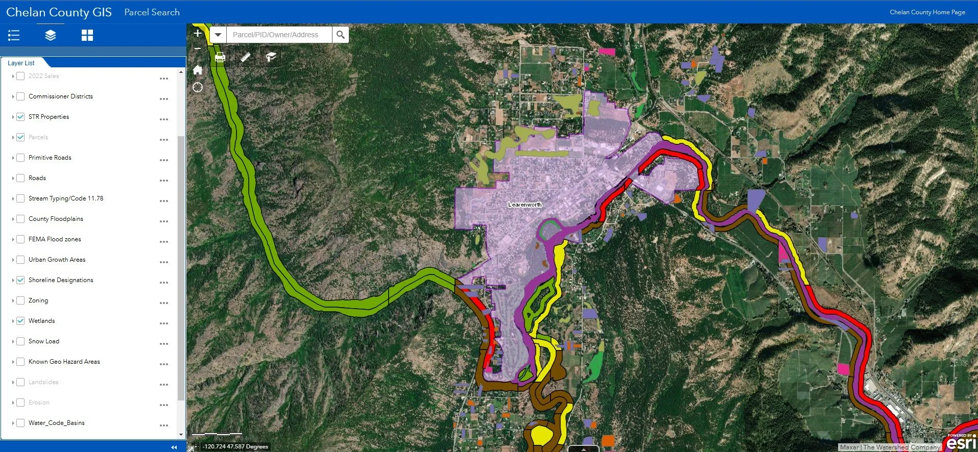
Chelan County GIS map example
Zoning maps & Land Use Code: These show designated land use zones (e.g., residential, commercial, industrial). To understand the implications of a property’s zone, we refer to the AHJ Land Use Codes, which provides specific zoning regulations that apply to the parcel. These codes dictate what can and cannot be done on the parcel and the process for documenting and reviewing property improvements. Depending on the zoning, certain uses may be permitted, such as accessory dwelling units (ADUs), commercial activities, or residential developments. We also find property development regulations that include restrictions on lot coverage, building setbacks, and height limits. These regulations ensure that development is consistent with community standards and environmental considerations.
Potential hazards: Flood zones, wetlands, and areas prone to erosion can be mapped using GIS data. This helps us inform the client about additional consulting services that may be required for their project. For example, a project on a shoreline may need an environmental engineer to assist with shoreline development, or a property with steep slopes may need a geologic hazard assessment.

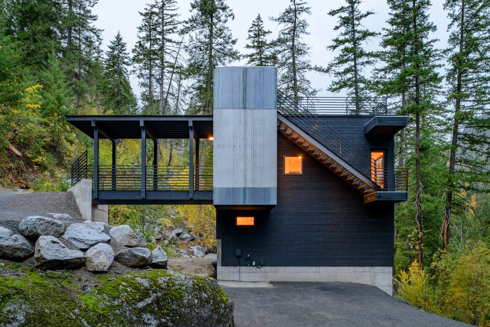
Residence on a steep sloped shoreline, Lake Chelan
Utilities and fire districts: Determining which fire district the parcel falls under is important for understanding emergency services and fire safety regulations, including whether your project may need to be sprinklered or have water tanks on-site for firefighting. Information about water, sewer, electricity, and other utilities is gathered, along with well logs and easements related to utilities. This information helps us plan for new infrastructure and how to get it to the property. We use local health districts and well recording websites to find additional information as needed.
What Land Studies Tell Property Owners
Land use studies have significant implications for both current and future landowners. These studies provide crucial information that impact how landowners can use their property and how their actions might affect their neighbors. Land use studies help landowners understand what they can and cannot do with their property and why. This includes knowing if they can build additional structures, keep certain animals (like goats!), or use the land for specific purposes. Property uses such as nightly rentals, wedding venues, commercial kitchens all have potential impacts on your neighborhood and are regulated by City or County Zoning. Understanding land use regulations helps landowners avoid conflicts with neighbors by respecting property boundaries, easements, and local ordinances.
Land use studies can reveal fascinating insights into local history and provide practical information for landowners. Sometimes, these studies uncover interesting historical facts about the land and its previous uses. Additionally, you can find out the taxes on the land you’re interested in purchasing. Want to know if you can keep a rooster, chicken, or goat? Or if you can park and live in your RV in your driveway? If you’ve been considering a home business, your AHJ and codes will let you know if that is possible or to what extent and what type of home business is allowed. Details such as these are often found in City or County codes and are worth looking through if you are planning any new development or uses for your property. While we don’t necessarily always need to check if a property can accommodate goats, you as a landowner might like to know if you can!
Summary of Information Sources
Information about land use is readily available to the public through various sources:
GIS (Geographic Information Systems): Provides detailed maps and spatial data.
Well Logs: Offer information about water sources and usage.
County/City Codes: Outline local regulations and permitted uses.
Assessor Information: Includes property values, ownership details, and tax information.
Recorded Documents: Such as deeds and easements, provide legal descriptions and restrictions.
Why does this matter for architectural design?
Understanding the land is crucial for designers to make informed decisions that enhance both the design and functionality of a project. Using the information we gather in our study and other pre-design services, we can make well-informed design decisions. Knowing the land’s topography and potential hazards helps in designing structures that maximize views and minimize risks. We can ensure that the design adheres to any legal restrictions or covenants associated with the property.
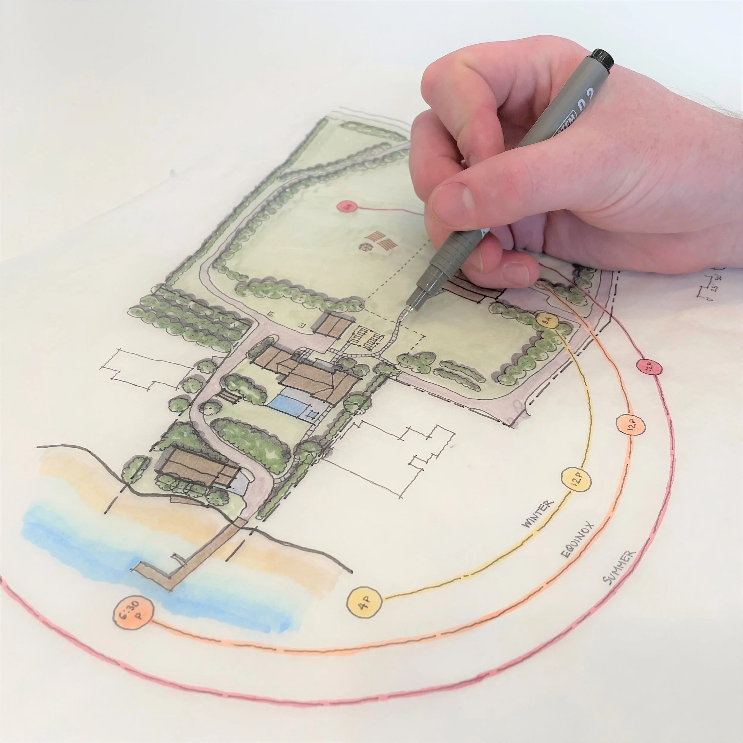
Hand drawn site plan example by Steven Booher, Partner & Principle Architect at Syndicate Smith
Conducting a land use study before starting the design process can significantly improve the outcome of a project. By having an in-depth understanding of site restrictions, hazards, and views, we can create a design that is both functional and aesthetically pleasing. Knowing what is allowed on the site helps in navigating the permitting process more efficiently, ensuring that the design respects existing easements and property boundaries.


Knowledge is Power
A land use study is an essential tool for anyone looking to develop, buy, or sell a parcel of land. It provides a detailed understanding of the land’s characteristics, potential uses, and any restrictions that may apply. By leveraging various data sources and understanding local regulations, stakeholders can make informed decisions about land use and development. Land use studies are invaluable for improving the design and permitting process. They provide a wealth of information that is accessible to the public, helping landowners and designers make informed decisions. By understanding the land, we can create better, more compliant, and more harmonious designs.
If you’re interested in a land use study for your property, reach out and tell us about your project—we’d be happy to explore how we can help!
Laurel Podlich, Architectural DesignerSyndicate SmithContact